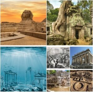
Colour this ancient map of Egypt to understand how its natural environments influenced how its pharaohs governed their empires. Discover why the Nile River played such an integral part of life for these rulers and how they navigated around its many cataracts for trade routes.
This georeferenced version of a Napoleonic map features text annotations to identify several features, such as valley route destinations and gold-mining settlement and quarry locations, as well as broken stone quarry locations.
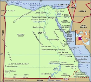
The Nile River
The Nile River runs along Egypt and creates a fertile floodplain that supports farming, providing stable population growth that led to a hieroglyphic writing system and monumental building projects. Furthermore, this natural resource was utilized as both food and wealth by Egyptians, who exploited its sources for themselves.
A strip of land along the riverbank became the epicentre of economic and cultural life in Egypt, evidenced by numerous temples, palaces, and pharaonic monuments depicted on maps.
Nile River transportation was essential in ancient Egyptian society. Boat builders excelled at creating large wooden vessels equipped with sails and oars as well as smaller papyrus reed skiffs attached to wooden frames; both types were crucial to mining sites, trade routes and transporting architectural elements like obelisks or architectural elements from distant places to distant tombs – not forgetting funerary purposes as part of afterlife celebrations or transport of deceased bodies into tombs.
As this map depicts, Egypt’s Nile River was an ever-evolving and changing geographical feature that marked its landscape. The Nile’s water levels fluctuated seasonally and were higher during rainy periods and lower during droughts; additionally, it could flood and bring untold destruction to entire communities along its course.
Another defining characteristic of the Nile was its cataracts, which could drastically change its course. At Aswan, for instance, its First Cataract abruptly turns the river into rapids, marking an inflexion point between Upper and Lower Egypt – while beyond this rapid was Nubia, an arid, inhospitable region which sometimes served as Egypt’s southern expansion target.
Ancient Egyptians were familiar with the Nile, from its source in Sudan to Lake Tana in Ethiopia, yet they showed little curiosity or interest in discovering where its Blue branch began or its source. Many did not even realize there were two branches – Blue and White.
The Desert
Ancient Egypt was situated in Northeastern Africa and consisted of four distinct geographical zones: Nile Delta, Western Desert, Eastern Desert and Floodplains. These landscapes determined how and where cities could prosper, as well as gave rise to certain religious associations; generally speaking, Egyptians associated life and abundance with the Nile Valley while they attributed death and chaos to surrounding deserts.
Egyptian rule extended beyond just the land surrounding the Nile River; their empire also included fertile oases in the Sahara Desert and ports on the Red Sea. Over their long history, Egyptians battled Canaanites from the south, Nubians from the west, Sea Peoples and Greeks from the north, and Persians and Assyrians from Mesopotamia, creating shifting frontiers under successive Pharaohs.
At its height in 2686 to 2181 BCE, Egypt experienced three boundary shifts with Libya and Sudan due to changes in both political situation and periodic floods from the Great Lakes region and Atlantic Ocean flooding.
These shifting boundaries may seem strange to modern eyes, but they were common practice among ancient Egyptians. They understood the need for an appropriate boundary to protect their homeland while also serving as a source of pride that showcased their king’s power and authority.
Egyptians were acutely aware of the Nile River as it traversed their land, using it as an integral feature to define their borders and establish new gods associated with its flow from south to north, such as those depicted by sema-tawny motifs used to depict Upper and Lower Egypt rulers by depicting gods as Nile plants such as papyrus for Lower Egypt and lotus for Upper Egypt.
This statement echoes a common perception that Egypt was “bounded by water.” However, this occurred during an unprecedented wet period that is no longer common to its region’s climate; since then, the Nile’s contours have shifted as well.
The Mediterranean Sea
Egypt was situated along the Mediterranean Sea, one of the world’s five great seas. Its coastal regions were blessed by wind from this body of water, while its fertile soils enabled Egyptians to cultivate wheat, flax and papyrus crops. Meanwhile, Nile River floodplains provided ample farming areas – home to Abydos, Edfu and Thebes, among many other important cities; its annual flooding also supported agriculture further south in Upper Egypt where important cities like Abydos, Edfu and Thebes could cultivate crops which could then be exported for sale in Upper Egypt.
Ancient Egyptians developed advanced farming techniques and irrigation systems to increase food production, including cultivating irrigated fields and developing irrigation systems. Furthermore, they perfected construction techniques by rapidly building massive stone pyramids using labour drawn from within their population.
Egyptians created numerous maps depicting not only topography and boundaries but other aspects of the universe, such as celestial bodies such as the sun and moon and even human anatomy. Furthermore, Egyptian maps also served to design relatively detailed plans of tombs built or planned by certain pharaohs – one such map can be found partially preserved among fifteen fragments of papyrus held at Turin’s Egyptian Museum.
This papyrus map includes a series of numbered text blocks which provide information such as the destinations of various routes along the river valley, gold deposits in hills, locations of gold-mining settlements and broken-stone quarries and the size of blocks quarried from them, the hieratic script used as cursive hieroglyphic writing; on map fragment one text identified its destination while another one located a tree that could possibly be identified as tamarisk on map fragment H and other texts identified the height and size of hills as well as specific ones which had been-stone blocks that had been quarried from them. These maps provided valuable insight into what were previously unknown places, also known as their placement among beken-stone deposits found along river valley routes, gold deposits found there, as well as settlement and quarry operations, which used hieratic script.
The Great Pyramids
The Great Pyramids–three massive monuments whose contours can be seen here–were constructed for three pharaohs of Ancient Egypt as tombs to rest their bodies after death. Their construction remains an object of widespread curiosity today; theories range from using ramps or even extraterrestrial assistance in building them; in reality, multiple methods were utilized.
The Nile River was the lifeblood of ancient Egypt. Flooding every year at around the same time, it carried rich sedimentation to fertile areas along its course and left fertile land behind for people to cultivate crops on. Over time, people settled the region, eventually creating two kingdoms – Upper Egypt along its narrow valley and Lower Egypt at its mouth in Lower Egypt’s broad delta delta region.
Egypt was known for its geological variety, including limestone, rock gypsum, sandstone and chert. The climate varied with hot desert temperatures during summers but precipitation and cooler conditions in northern parts of the country during colder periods.
Egyptian artisans produced more than just maps depicting topography; they also created relatively detailed plans of either projected or completed royal tombs, featuring illustrations naming each Pharaoh and detailing his role within society and beyond. Such displays would often be displayed in temples as guidance for an afterlife journey.
This map features several inset maps which detail some of the major sites of Ancient Egypt. These include plans of temples at Karnak and Luxor, as well as Giza’s pyramids and Abusir’s necropolis.
Amennakhte was the creator of this map. His signature handwriting can be seen on the back side of the papyrus as its source. Amennakhte may have served as part of Khufu’s court scribes during its construction of the Great Pyramid; perhaps he oversaw its assembly. Amennakhte provides us with a fascinating glimpse into this complex process through his map.